Tutte le attività
Questo elenco si aggiorna automaticamente
- Ultima ora
-

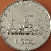
5 soldi 1744 Carlo Emanuele III
Carlo. ha risposto a un topic di Carlo. inviato in Monete e Medaglie dei Savoia prima dell'unità d'Italia
buongiorno, non era mio intento mettere in discussione il tuo parere, ma per mera curiosità ho voluto confrontarmi con un perito che sicuramente ne sa più di me, anche dal vivo per poter approfondire meglio, più di quanto si possa effettivamente fare in uno scambio di messaggi sul forum. sinceramente a me non cambia molto possedere un esemplare comunissimo o raro o falso, mi interessa maggiormente il "che cosa ha rappresentato" nella vita quotidiana: è una monetina che ha sicuramente circolato ed è stata scambiata per operazioni quotidiane e ha fatto il suo dovere, vera o falsa che fosse. e chiarisco anche che il mio interesse non è minimamente economico, non ho intenzione di vendere i pezzi della mia collezione. peraltro, non ricordo se ho già dichiarato che il prezzo di acquisto è stato di 8 euro, quindi piuttosto irrilevante, anche si trattasse di un falso d'epoca. grazie ancora per i preziosi contributi -

news e informazioni filateliche Notizie da Unificato & Vaccari.
PostOffice ha risposto a un topic di PostOffice inviato in Filatelia e Storia Postale
Traduzione dell' articolo sottostante: Prima di esaminare i francobolli utilizzati negli anni 1840 e 1850, resta da considerare un altro gruppo di marchi postali generali precedenti, ovvero quelli comunemente noti come "Marchi aggiuntivi". Una legge del Parlamento approvata nel 1813 stabilì che le diligenze postali con più di due ruote non sarebbero più state esenti dal pedaggio. La Sezione VI della legge prevedeva inoltre che, a titolo di compensazione per tale onere, il Direttore Generale delle Poste potesse imporre a tutte le lettere e i pacchi trasportati da o verso qualsiasi località della Scozia da tali diligenze postali un supplemento di mezzo penny. In una lettera a noi indirizzata in cui si discute di questa tassa, il signor G. Brumell afferma: "Alcune città scozzesi erano servite da posta a cavallo o a piedi, o da carri a due ruote, e le lettere provenienti da tali città non erano soggette a tassa, a meno che non viaggiassero con le diligenze postali; quindi una lettera da Jedburgh a Hawick viaggiava a cavallo e non era soggetta a tassa, ma se superava Hawick sulla strada postale, era soggetta alla "tassa aggiuntiva". Non credo che nessuna lettera potesse arrivare in Inghilterra se non in diligenza postale". Contrassegni speciali per indicare la tassa aggiuntiva entrarono in uso presso molti uffici e numerose varianti furono impiegate tra il 1813 e il 1840. Le figure da 503 a 508 illustrano esempi tipici. Tutti questi tipi sono disponibili in diverse dimensioni e vi sono lievi variazioni nella forma e nelle dimensioni delle lettere e delle cifre. La barra tra le cifre nel tipo mostrato nella figura 507 ha un'inclinazione variabile e può anche essere trovata correndo verso il basso a destra o diagonalmente verso il basso a sinistra da un angolo all'altro. Di norma, questi segni "d. aggiuntiva" erano impressi in nero, ma abbiamo visto esemplari dei tipi illustrati nelle Fig. da 506 a 508 in blu, nero e verde ed esempi in rosso nelle Fig. 507 e 508. -
Marengo Umberto I 1882 -Verifica autenticità-
Carlo. ha risposto a un topic di Bolio inviato in Richiesta Identificazione/valutazione/autenticità
buongiorno, mi pare che i dettagli, nel confronto tra le due monete, siano poco definiti e un minimo pasticciati nell'esemplare oggetto di discussione -
5 soldi 1744 Carlo Emanuele III
savoiardo ha risposto a un topic di Carlo. inviato in Monete e Medaglie dei Savoia prima dell'unità d'Italia
Capisco l'interesse che può suscitare questa moneta, ma dalle prove in nostro possesso rimane la probabilità che si tratti di un falso d'epoca.. Tutti gli esemplari che abbiamo rintracciato e ben documentato in questa discussione lo provano, errori in fase di catalogazione delle monete, anche da parte degli esperti del settore, capitano e vengono poi tramandati sulla fiducia nelle pubblicazioni successive... Io personalmente rimango convinto delle conclusioni che abbiamo tratto in questa discussione, anche se , come sempre, sono pronto a cambiare idea nell'ipotesi di rintracciare un esemplare del 44 non proveniente dallo stesso conio di questi che abbiamo potuto vedere. Per me resta un falso -
news e informazioni filateliche Notizie da Unificato & Vaccari.
PostOffice ha risposto a un topic di PostOffice inviato in Filatelia e Storia Postale
Solitamente quando trovo ritagli di cataloghi o informazioni sul web di questo tipo, le salvo in memoria e le stampo su cartaceo per poi metterle in un raccoglitore ad anelli che tengo sempre in libreria, negli anni mi sono reso conto che conservare informazioni e' importante in quanto i cataloghi si rinnovano e spesso omettono informazioni forse per motivi di spazio o di economia importanti. Chi li volesse salvare o scaricare ben venga, sono qui. Sono in lingua originale inglese ma per semplicità le posto gia' tradotte in italiano. Annulli vittoriani inglesi. -
XVIII° sec. ti sembra poco?
-

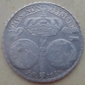
MEZZO TALLERO FOTO
sergio sebastiani ha risposto a un topic di sergio sebastiani inviato in Zecche Straniere
ecco le foto -
news e informazioni filateliche Notizie da Unificato & Vaccari.
PostOffice ha risposto a un topic di PostOffice inviato in Filatelia e Storia Postale
L'articolo e' tratto da un saggio del grande Carlo Sopracordevole che e' stato uno dei più grandi specialisti italiani d'interi postali. -
Curiosità nella lingua italiana: aforismi, battute, aneddoti, ecc.
macs ha risposto a un topic di apollonia inviato in Agorà
UNO, NESSUNO E CENTOMILA -

120 grana 1795 vero? o falso ?
motoreavapore ha risposto a un topic di SELLY inviato in Monete e Medaglie delle Due Sicilie, già Regno di Napoli e Sicilia
Buongiorno, anche per me, dai caratteri dello stemma al rovescio e dall'effige al dritto, sembra buona. Noto però che la legenda, specialmente al rovescio, non ha nessun margine con il bordo del taglio. Sembra essere proprio al limite ma la moneta è perfettamente rotonda, quindi escluderei la tosatura e propenderei pure io per la coniazione su un tondello più piccolo. (100 grana) Naturalmente peso e diametro, effettuato con strumenti idonei e foto ravvicinate di tutto il taglio, sarebbero dirementi. Comunque alla fine per me resta sempre una bella SIGILIAR -
di che città?
Alan Sinclair ha risposto a un topic di Numi 62 inviato in Richiesta Identificazione/valutazione/autenticità
Buongiorno @Numi 62, mancherebbe l'allegato-foto della moneta. Grazie 🙂 -
news e informazioni filateliche Notizie da Unificato & Vaccari.
PostOffice ha risposto a un topic di PostOffice inviato in Filatelia e Storia Postale
-
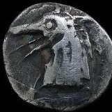
di che città?
Numi 62 ha aggiunto un nuovo link in Richiesta Identificazione/valutazione/autenticità
Buongiorno a tutti invio foto di una moneta greca non in mio possesso quindi non posso indicare peso e diametro sembrerebbe in argento. potrebbe essere di Motia? grazie in anticipo - Oggi
-
Immagini declassificate dai satelliti spia americani della Guerra Fredda rivelano CENTINAIA di forti romani perduti in Siria e Iraq
ARES III ha risposto a un topic di Vel Saties inviato in Rassegna Stampa
C'è stato qualche tempo fa (3/4 settimane) anche un documentario su Focus. Dovrebbe essere questo: https://mediasetinfinity.mediaset.it/video/vistidalcielomisteridiquestomondo3/ep-2-luoghi-deserti_F313130301000204 PS: naturalmente non è che sia scientificamente così fatto bene, ma le immagini possono rendere bene il contesto -
Che monete sono?
Numi 62 ha risposto a un topic di leonardo s. inviato in Richiesta Identificazione/valutazione/autenticità
132: R/ REX.SICILIE sigla i - c 133: R/ REX: SICILIE:A sigla m - c 134 R/ REX:SICILIE:I 134A : R/REX SICILIE I Sigle M-C -

120 Grana 1855 bordo rigato
ilnumismatico ha risposto a un topic di Gordonacci inviato in Monete e Medaglie delle Due Sicilie, già Regno di Napoli e Sicilia
Questa è una piastra che anche se non FdC, ha un appeal decisamente fuori dal comune. Anche qui ci sono i classici difetti di conio, compresi quelli del bordo che reputo sovrapponibili all'esemplare in esame. Quindi, prima di bistrattare la qualità di un esemplare per gli usuali difetti tecnici che contraddistinguono l'attività della relativa zecca, è fondamentale conoscere e saper distinguere queste peculiarità. -
120 Grana 1855 bordo rigato
ilnumismatico ha risposto a un topic di Gordonacci inviato in Monete e Medaglie delle Due Sicilie, già Regno di Napoli e Sicilia
Confermo quanto già scritto precedentemente. I frame tratti dal video non sono esplicativi, in quanto continuano a essere abbondantemente sovraesposti e a non mostrare l'effettiva brillantezza del metallo. Per comparazione allego due mie ex Piastre, FdC, dove si notano i sopracitati difetti di coniazione (debolezze) sul ciuffo dei capelli (1853) e sui gigli (1856). Nella monetazione Borbonica i rilievi non sono MAI indicativi del grado di conservazione perchè soggetti a difetti di conio. -
Immagini declassificate dai satelliti spia americani della Guerra Fredda rivelano CENTINAIA di forti romani perduti in Siria e Iraq
Vel Saties ha aggiunto un nuovo link in Rassegna Stampa
LA NOTIZIA NON E' NUOVA, ESSENDO DATATA AL 2023, MA PUR SEMPRE INTERESSANTE. FONTE: https://dailytopis.com/declassified-images-from-american-cold-war-spy-satellites-reveal-hundreds-of-lost-roman-forts-across-syria-and-iraq/?fbclid=IwY2xjawNDEPJleHRuA2FlbQIxMABicmlkETFMSWR1ZnozNnY5a2dtbWVlAR7R_1GkKQOkGVhWRrkAVk6jrgK4abVSNJpdziymumSgP95oNZZTKdW1lhtKmw_aem_aaimQH2m3fPL_ceghfZoUg Declassified images from American Cold War spy satellites reveal HUNDREDS of lost Roman forts across Syria and Iraq American satellites that were built to keep an eye on the Russians during the Cold War are now yielding fascinating secrets about the Roman Empire. Researchers have studied satellite imagery that provides a unique snapshot of the Syrian Steppe in the 1960s and 1970s, in what is now Syria and Iraq. The experts identified the remains of 396 Roman forts – buildings that acted as bases for Roman troops during the days of the Empire nearly 2,000 years ago. Because of the unique layout of the forts – scattered all over the region rather than forming a line – the team believe they acted as bases and facilitated ‘the movement of people and goods’. Researchers have studied satellite imagery that provides a unique snapshot of the Syrian Steppe in the 1960s and 1970s, in what is now Syria and Iraq. The experts identified the remains of 396 Roman forts – buildings that acted as bases for Roman troops during the days of the Empire nearly 2,000 years ago. Because of the unique layout of the forts – scattered all over the region rather than forming a line – the team believe they acted as bases and facilitated ‘the movement of people and goods’. Archeologists studied declassified spy satellite imagery from the 1960s and 1970s (pictured) to find forts in part of the Roman Empire Researchers have studied satellite imagery that provides a unique snapshot of the Syrian Steppe in the 1960s and 1970s, in what is now Syria and Iraq. The team’s study area is highlighted in red But the new study – conducted by researchers at the Department of Anthropology, Dartmouth College in Hanover, New Hampshire – shows this may not always have been the case. The team say their results have ‘dramatic implications’ for modern understanding of Roman life. ‘We argue that most – but certainly not all – of the fort sites documented in this study are likely to be Roman and late Roman in date,’ they say. ‘The structures played a role in facilitating the movement of people and goods across the Syrian steppe.’ It’s already known that the Syrian steppe was the location of many forts built by the Romans (although, due to the vastness of the Empire, fort remains can be found all over Europe, including in Britain). Even if no traces of the constructions can be seen by the naked eye on the ground, their imprint on the landscape can be picked up by aerial imagery, often using light sensing methods. An initial survey of the Syrian Steppe was published by pioneering French archeologist Antoine Poidebard in 1934, who took aerial photos from his biplane. He recorded a line of 116 forts and noted that their position formed a line and corresponded with the eastern frontier of the Roman Empire. Because of this, Poidebard was sure the forts acted as a defensive line to protect the eastern provinces from Arab and Persian incursions from the west. Pictured, the 1934 aerial photographs of select Roman forts in the region surveyed by French archeologist Antoine Poidebard The study authors were able to identify 396 Roman forts – buildings that acted as bases for Roman troops during the days of the Empire nearly 2,000 years ago. Depicted here is Roman fort at Portchester, England in AD 345 ‘Since the 1930s, historians and archaeologists have debated the strategic or political purpose of this system of fortifications,’ said lead author of the new study Professor Jesse Casana at Dartmouth College. ‘But few scholars have questioned Poidebard’s basic observation that there was a line of forts defining the eastern Roman frontier.’ For the study, the team wanted to see if they could find evidence of extra forts that Poidebard had not found, which could potenitally challenge the Frenchman’s assumptions. They used declassified spy satellite imagery from the Cold War – two different programmes codenamed Corona and Hexagon. ‘These images formed part of the world’s first spy satellite programmes, with Corona imagery collected from 1960 to 1972 and its successor, Hexagon imagery, collected from 1970 to 1986,’ the authors say. By using the forts found by Poidebard as a reference point, the team was able to identify an extra 396, bringing the total to 512. But what was interesting was they were found widely distributed across the region from east to west, which does not suggest they together formed a border, as Poidebard had believed. Instead, the researchers think the forts were constructed to support trade between the region and protect Roman caravans travelling between the eastern provinces and non-Roman territories. Meanwhile, the distribution of Poidebard’s forts is merely a product of ‘discovery bias’, the team claim. ‘The addition of these forts questions Poidebard’s defensive frontier thesis and suggests instead that the structures played a role in facilitating the movement of people and goods across the Syrian steppe,’ they write. They used declassified spy satellite imagery from the Cold War – two different programmes codenamed Corona and Hexagon. Pictured is the Hexagon satellite vehicle Distribution maps of forts documented by (top) French archeologist Antoine Poidebard nearly a century ago, compared to (bottom) distribution of forts newly found on satellite imagery Images from the Corona US spy satellite programme revealing some of the Roman forts ‘Such forts supported a system of caravan-based interregional trade, communication and military transport.’ Already, recent research has reimagined Roman frontiers as sites of ‘cultural exchange’ rather than barriers where bloody conflict was constantly held. Although conflict likely occurred at the forts, this was likely not their sole purpose, the experts suggest. And although the Romans were a military society, they valued trade and communication with regions that were not under their direct control. ‘We can similarly view the forts of the Syrian steppe as enabling safe and secure transit across the landscape, offering water to camels and livestock, and providing a place for weary travellers to eat, drink and sleep,’ the team add. This indicates that the borders of the Roman territory were less rigidly defined and perhaps not the centres of bloodshed and conflict as previously thought. Because the declassified satellite images are around half a century old, many of the forts have since been destroyed by urban or agricultural development, the team say. Hopefully, as more declassified imagery, such as U2 spy plane photos, become available, new discoveries could be made and archeological sites could be saved. LEGGI ANCHE: https://www.smithsonianmag.com/smart-news/declassified-cold-war-photos-reveal-hundreds-of-unknown-roman-era-forts-180983151/ https://edition.cnn.com/2023/10/25/world/roman-forts-spy-satellite-photos-scn https://www.nationalgeographic.com/history/article/roman-forts-archaeology-cold-war-spy-satellite-photos https://www.ancient-origins.net/news-history-archaeology/roman-fort-images-0019681 https://www.arabnews.com/node/2398011/amp -

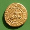
Marengo Umberto I 1882 -Verifica autenticità-
SicilianoMagnoGreco ha risposto a un topic di Bolio inviato in Richiesta Identificazione/valutazione/autenticità
Buongiorno, credo che per perlinatura, firme ec.. la campana a morto sta suonando. -
Marengo Umberto I 1882 -Verifica autenticità-
Alan Sinclair ha risposto a un topic di Bolio inviato in Richiesta Identificazione/valutazione/autenticità
Confermo i dubbi che già avevo espresso per i dati ponderali, la moneta non mi convince. -
1 Soldo 1813, cosa può essere successo...
ilnumismatico ha risposto a un topic di ilLurkatore inviato in Monetazione degli Stati Preunitari (1800-1860)
Sembrerebbe battuta fuori virola. Potresti indicare il diametro preciso? E se puoi, anche il peso Sentiamo @lorluke che è specialista -

120 grana 1795 vero? o falso ?
gennydbmoney ha risposto a un topic di SELLY inviato in Monete e Medaglie delle Due Sicilie, già Regno di Napoli e Sicilia
Direi di sì,per questo ho chiesto all' utente SELLY con che strumenti ha rilevato peso e diametro... -
5 lire Aquilotto 1926
SicilianoMagnoGreco ha risposto a un topic di Atexano inviato in Regno d'Italia: identificazioni, valutazioni e altro
Buongiorno, concordo con i consigli di @Carlo. e @caravelle82. Utilizzando le capsule limiti al minimo il contatto con l'aria. -
Marengo Umberto I 1882 -Verifica autenticità-
caravelle82 ha risposto a un topic di Bolio inviato in Richiesta Identificazione/valutazione/autenticità
La perlinatura é troppo "tondeggiante" vero? -
120 grana 1795 vero? o falso ?
fricogna ha risposto a un topic di SELLY inviato in Monete e Medaglie delle Due Sicilie, già Regno di Napoli e Sicilia
Le rare piastre coniate sui tondelli dei ducati hanno il diametro più stretto, come appunto quello dei ducati?